Mares during the period known as the “Time of Oceans.”
(Click image to enlarge)
-
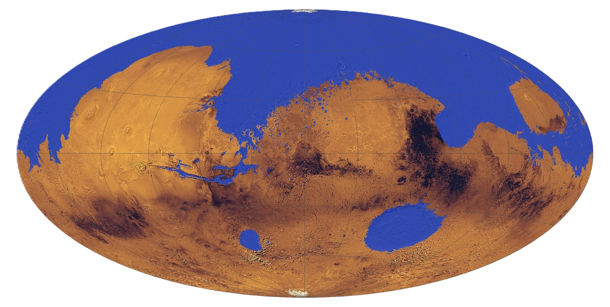
This reconstruction synthesizes stratigraphic, sedimentological, and geomorphological data compiled by the Helium Academy of Geology. The analysis draws upon basin mapping, lithologic surveys, paleo-shoreline indicators, and glaciological studies to characterize the major physiographic provinces during the planet’s Oceanic Epoch.
It should be noted that while some debate remains, most assessments conclude the planetary ocean was a recent (in geologic terms) formation and composition of planetary water samples suggests off-world origins for the oceanic water. However, it is unknown by what method such large volumes of water could have arrived at the planet so late in the solar-system’s life cycle.
Addendum: At present there is insufficient evidence beyond that recorded in the Memoirs of Xanthea of Helios to support hypotheses that advanced technologies may have been involved in the planetary scale engineering at some point in the planet’s past.
-
Sedimentary sequences and coastal terrace formations indicate that the planet was once extensively covered by standing bodies of water.
The Northern Hemisphere was dominated by a hemispheric-scale oceanic basin, identified in historical records as the Great Ocean. Shoreline scarps, deltaic deposits, and thick marine sedimentary strata confirm prolonged stability of this basin over a significant interval.
Four major inland seas were also present during this period. The first, identified as the Xanthe Sea, occupied a predominantly north–south trending structural depression. Lithofacies distributions and shallow-marine deposits indicate that it was a relatively low-gradient epicontinental sea.
Paleogeographic reconstructions suggest that this basin functioned as a hydrologic separator between the principal urban centers of Helios and Linium during the late Oceanic phase.
The second major basin, the Marians Sea, extended along an east–west axis and represents the deepest known marine depression on the planet during this epoch. Bathymetric modeling and sediment thickness analyses suggest it was the final major marine reservoir to persist as global water volumes declined or sublimated into subsurface deposits and seas.
Two additional inland seas, the easternmost identified as the Agrye Sea, and the western as the Hellas Sea. Both seas were likely formed within ancient pre-existing impact basins during this epoch.
-
The Southern Hemisphere was dominated by a large continental landmass.
Paleogeographic evidence supports the existence of a subsidiary island continent situated north of the southern landmass and separated by a shallow marine channel. Isostatic rebound modeling and sediment infill patterns indicate that this channel was rapidly infilled or exposed as sea levels regressed, reestablishing continental continuity.
The southern continental mass can be subdivided into distinct geological provinces. The eastern sector, corresponding to the Tharsis region, was characterized by extensive shield volcanism. Volcanic constructs and associated lava plains dominate the stratigraphy, indicating sustained magmatic activity.
The southern interior plains were marked by two broad, shallow inland seas as noted earlier. Their limited depth and position within an increasingly arid climatic zone suggest they were among the first major water bodies to undergo sublimation and desiccation.
The western portions of the southern continent consist primarily of expansive lowland plains exhibiting limited fluvial incision and sparse vegetative signatures, consistent with progressive aridification during the regression phase.
Polar surveys confirm the presence of substantial ice caps at both the northern and southern poles. Stratigraphic ice-layering and glacial-flow indicators indicate long-term cryosphere stability during and after the Oceanic Epoch.
The Omean sub-polar glacial sea appears to have survived the loss of the majority of global aridification, likely due to its protective enclosure and sublimation of polar ice that replenished the ocean over time.
-
Studies suggest the loss of the planetary hydrosphere was rapid on geologic timescales. Estimates range from 5,000 to 10,000 years.
Primary factors contributing to the rapid aridification appear to be the effects of solar wind stripping and the planet's lower gravitational protection compared to other planets.
The rapid loss of the global hydrosphere is a strong indication that this epoch was not a natural geological or climatic event, but was influenced by unidentified factors.
-
It should be noted that many of the geomorphological features described herein exhibit significant erosional modification. Aeolian abrasion, mass wasting, glacial scouring, and long-term sublimation have reduced the vertical relief of volcanic edifices, coastal escarpments, and basin margins, complicating precise paleo-topographic reconstruction.
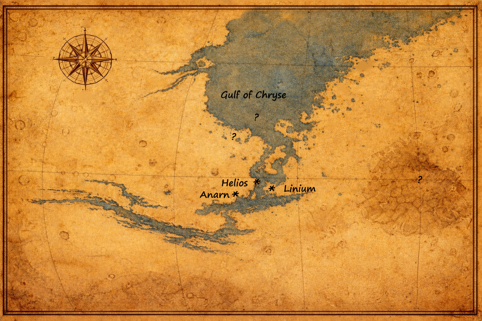
Mares Period Map
(Click to enlarge)
-
This map, found in a cache of personal effects belonging to Xanthea of Helios, largely echoes modern reconstructions. It also provides several locations consistent with archeological finds at the marked locations, lending authenticity to its accuracy.
-
This recovered map from the period has been restored. It indicates substantial cartography skills, which would be typical of a nautical power.
-
The marked locations appear to accurately identify several key locations including Greater and Lesser Helium as well as other well know sites. Several of the other unidentified locations have been marked for excavations in the near future.